Land
Why should we care?
Geographical location at the crossroads of major natural units enabled high landscape diversity and biodiversity. Because of the varied relief, there are relatively limited flatlands which consequently leads to a conflicts of interest among different land uses.
Slovenia’s geostrategic position, its size and the gravitation of inhabitants from border areas to more powerful urban centres outside the country demand heightened concern for the preservation of the country’s identity and effective management of its physical environment.
Alongside historical factors, spatial development in Slovenia has been defined by the natural characteristics of the environment, provided by its separation into Alpine, Dinaric-Karst, Mediterranean and Pannonian areas. Slovenia is characterised by varied relief, a large proportion of karstic terrain, relatively limited flatlands, a wealth of surface and groundwater, proximity to the sea, biodiversity, diversity of landscape, preservation of cultural heritage and extensive forest cover. The fertile flat bottoms of Alpine basins and valleys, the Pannonian Plain and the coastal area are favourable for agriculture, construction of transport infrastructure and industrial facilities and also for the expansion of settlements, which often leads to a clash of interests. The gravelly flat land of the basins is also an important and vulnerable source of drinking water, which is for the most part threatened by emissions of wastewater and excessive use by agriculture of mineral fertilisers and plant protection agents.
Since the earliest times, geographical features have favourably affected the ease of transiting Slovenian territory. This can be seen today in the Slovenian transport cross, which links European overland transport routes and, via one leg, is connected to the sea through the port at Koper.
Slovenia also features a diversity of settlement structures, with a large number of small settlements and numerous areas of diffuse settlement, plus a relatively high standard of living in its fairly unpolluted environment. The role and importance of the countryside have also changed as a result of the penetration of an urban way of life and non-farming activities (MOP, 2002).
The sea is an exceptionally important asset. Even though Slovenia has a coast of 46.6 km, it represents an important natural resource and natural wealth, which has facilitated the development of various tourist and transport activities, and it also has an important symbolic value for the country’s inhabitants.
What are the state and impacts?
More than half of the land surface is covered with forests, artificial surfaces represent less than 3 %. Their share is increasing mainly due to the construction of transport infrastructure. The majority of forests have been grubbed for the needs of the latter and in smaller extent of agricultural areas.
More than half of Slovenia’s land surface is covered with forest.
More than half of Slovenia’s land surface is covered with forest, 56 % and 58 % when transitional woodland-scrub is taken into account; other mainly natural areas, natural grassland, wetlands, water bodies, open spaces with little or no vegetation, take up 4 %, 35 % of the surface is intended mainly for farming, while just under 3 % has artificial surfaces (TP01). This picture of land cover and use can be seen in the satellite pictures taken in 2006 according to the CORINE Land Cover methodology (CLC2006).
The forest area is increasing where there is already forest cover but in areas of intensive farming and especially in suburban areas there is pressure on forests which is leading gradually, despite conservation efforts, to shrinkage of what are already tiny remnants of forest (GZ05). A large proportion of relatively inaccessible forest is the main reason why humans had a less critical impact on forests in the past, than in the majority of Central European countries. For this reason the forests are relatively well preserved, especially as regards the diversity of the natural make-up of tree species and, vertically and horizontally, the structure of stands (GZ02).
As far as high-quality landscape is concerned, within the framework of natural features there is a mosaic-like interweaving of forest and farmland. These categories of land, labelled by CLC2006 as complex cultivation patterns and land principally occupied by agriculture with significant areas of natural vegetation, occupy 23 % of Slovenia. While the fragmentation of farmland is not desirable from the aspect of the economics of farm production, in terms of cultural landscape the diversity and landscape patterns and the interweaving of uses encourage greater biodiversity and represent the natural and cultural heritage and identity of the Slovenian landscape (TP01).
The same methodology was applied in 2000 (CLC2000) and 1996 (CLC95), so an analysis of changes is possible. These are relatively small and in none of the periods covered do they represent more than around 0.1 % of the entire territory. Account needs to be taken of the fact that the methodology used only covers land cover changes greater than 5 ha.
Analysis of the course of changes (Figure 2) between individual types of land cover and use (LEAC) has shown that the biggest changes took place in forest areas. Between 1996 and 2000, around 520 ha of forest land was felled and reforested, mainly in deciduous forests, and between 2000 and 2006 this was done over 1 700 ha of mainly evergreen forests. Areas of transitional woodland scrub identified by the methodology occupied 150 ha. The shrinking of forests was also necessary for the construction of infrastructure (TP01).
Around 60 % of newly sealed surfaces were previously forest, and the remaining third was farmland, of which 210 ha were complete field areas. Almost all of it was developed after 2000 (Table 1, Figure 3).
Table 1: Land cover categories being taken by urban and other artificial land development
| land cover categories | uptake in ha | ||
| 1996-2000 | 2000-2006 | total 1996-2006 | |
| arable land and permanent crops | 8,11 | 202,75 | 210,86 |
| pastures and mixed farmland | 110,44 | 216,08 | 326,52 |
| forests and transitional woodland shrub | 170,7 | 672,3 | 843 |
| natural grassland, heathland, sclerophyllous vegetation | 26,93 | 0 | 26,93 |
| open spaces with little or no vegetation | 0 | 0 | 0 |
| wetlands | 0 | 0 | 0 |
| water bodies | 0 | 0 | 0 |
| total change of the period | 316,18 | 1091,12 | 1407,3 |
Source: CLC95, CLC2000 and CLC2006. Ministry of the Environment and Spatial Planning, Slovenian Environment Agency, Surveying and mapping Authority of the Republic of Slovenia, European Environment Agency, 2007.
The transport network and infrastructure account for almost two-thirds, 62 %, of the entire increase in urban and other artificial surfaces. Average annual change in the period 1996-2006 amounted to 87 ha/year (Table 2, Figure 4).
Table 2: Land uptake by sector
| types of human activity | uptake in ha | |||
| 1996–2000 | 2000–2006 | total 1996–2006 | per year | |
| land uptake by housing, services and recreation | 11,37 | 151,34 | 162,71 | 16,27 |
| land uptake by industrial and commercial sites | 43,52 | 68,22 | 111,74 | 11,17 |
| land uptake by transport networks and infrastructures | 177,56 | 694,05 | 871,61 | 87,16 |
| land uptake by mines, quarries and waste dumpsites | 83,73 | 177,5 | 261,23 | 26,12 |
| total artificial land cover uptake | 316,18 | 1091,11 | 1407,29 | 14,73 |
Source: CLC95, CLC2000 and CLC2006. Ministry of the Environment and Spatial Planning, Slovenian Environment Agency, Surveying and mapping Authority of the Republic of Slovenia, European Environment Agency, 2007.
A review of the compositional quality of urbanised land shows that, to a great extent, better quality land has been built on with settlements chiefly concentrated at the bottom of river valleys and on flood plains along rivers where the soil is of the highest quality. Across Slovenia as a whole, around half the land is of medium quality, while 29 % is higher-quality soil. Of the surface areas that were urbanised in 2002–2007, as much as 43 % occupied the highest-quality land, while 36 % covered medium quality soil. Space in Slovenia is a limited and precious natural resource, so the urbanisation of the past decade is worrying – higher-quality agricultural land is being lost in a country where a considerable proportion is mountainous and with very little high-quality soil and farmland (KM10).
Figure 1: Composition of land cover and use in Slovenia in 2006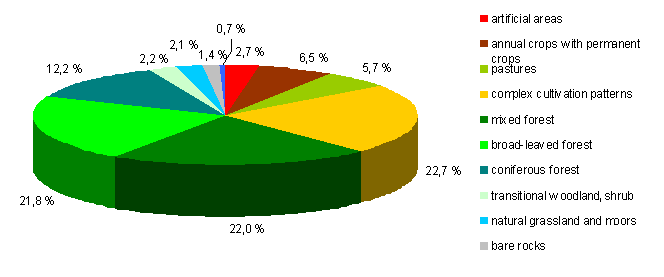
Source: CLC2006. Ministry of the Environment and Spatial Planning, Slovenian Environment Agency, Surveying and mapping Authority of the Republic of Slovenia, European Environment Agency, 2007 (Ref: Environmental Indicators in Slovenia, TP01)
Figure 2: Course of changes to land cover (analysis using LEAC methodology)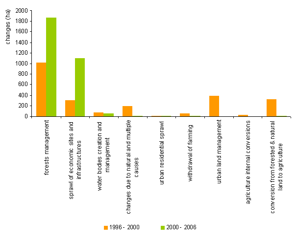
Source: CORINE Land Cover 2000 and 2006. Ministry of the Environment and Spatial Planning, Slovenian Environment Agency, Surveying and mapping Authority of the Republic of Slovenia, European Environment Agency, 2003 and 2007 SprePok-SI. Slovenian Environment Agency, 2008 (Ref: Environmental Indicators in Slovenia, TP01)
Figure 3: Categories of cover sealed urban and other artificial surfaces (1996–2006)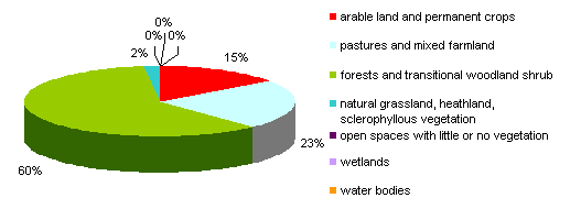
Source: CLC95, CLC2000 and CLC2006. Ministry of the Environment and Spatial Planning, Slovenian Environment Agency, Surveying and mapping Authority of the Republic of Slovenia, European Environment Agency, 2007
Figure 4: Land uptake by sector in hectares per year, 1996–2006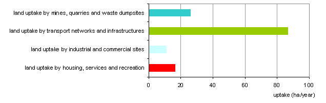
Source: CORINE Land Cover 1995, 2000 and 2006. Ministry of the Environment and Spatial Planning, Slovenian Environment Agency, Surveying and mapping Authority of the Republic of Slovenia, 2007
Figure 5: Soil quality in urbanised areas, 2002–2007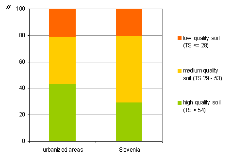
Source: Soil quality of urbanised areas, Agricultural Institute of Slovenia, Centre for Soil and the Environment, 2008 (Ref: Environmental Indicators in Slovenia, KM10)
What are the related drivers and pressures?
The transformation of the physical environment to date has been largely haphazard, and can be seen in the tendency of diffuse construction outside dense settlements and the undermining of the cultural landscape and settlement heritage. Major changes have been observed on the margins of settlements as a result of the needs of industry and commerce and in motorway corridors. The overgrowing of arable land and the construction of transport and energy infrastructures are also contributing to the visible transformation of the physical environment.
Slovenian landscape is changing.
With a population of 2 million, 0.5 % of the EU population, and population density of 100 people per km2, Slovenia ranks as a quite sparsely populated European country. Owing to the hilly terrain, the population is unevenly distributed, and differences resulting from long-term thinning in remote, mainly mountainous and border areas or agglomeration in cities are increasing. There is typically dense settlement of valley and plain areas, and almost 60 % of the entire population lives in less than 20 % of the country’s territory. The population density is low in hilly sub-Alpine and Dinaric-Karst areas, where small diffuse settlements with a negative migration balance and ageing of the population predominate. Similar trends apply to the areas bordering neighbouring countries (ARSO, 2008, MKGP, 2009).
For decades the number of households has been increasing while the number of members in individual households has declined. The number of dwellings has also grown, by 72 % from 1971-2007. In the same period the number of households grew by 45 %, but the population grew by only 17 %. The average surface area of residential unit per person has also increased, possibly because more people are living singly and the rise in ownership of multiple residential units (PG02,PG03).
Slovenian urbanisation is characterised on the one hand by diffuse settlement with a large number of small settlements, overall a total of nearly 6 000 over 20 000 km2, and on the other hand urban concentrations in the valleys and plains. Over the last ten years the trend has been of increasing diffuse construction close to settlements and in the countryside. Major changes have also been observed on the margins of settlements as a result of the needs of industry and commerce and in motorway corridors. An important share is held by the small-scale but numerous and diffuse construction of individual residential buildings, the renovation, expansion and modernisation of residential structures and the construction of small-scale infrastructure (KM10). Growth is being seen primarily in small settlements close to the largest cities, where major investments are needed for the adequate provision of municipal services and infrastructure. Expanding settlement and the development of settlements in such areas often conflict with the preservation of high-quality land for farming, which is predominant in the lowland plains.
An increasing inflow of residents and construction trends are also being observed along Slovenia’s coastal short belt, where other activities, tourism, transport, etc., are being concentrated. Today the entire coastal belt is densely populated, and pressures to build holiday homes, tourist facilities and marinas, which impact the characteristics of the coastal landscape, are great. Increasing pressure on the coastal belt can also be seen in the transformation and consolidation of the shoreline. Only 25 % of the coast is still in its natural state. 38 % has been moderately altered, while the remaining 37 % has been markedly or radically changed. The last category includes ports, marinas and urban areas which encroach on the tidal zone and sea. Along 12 % of the coast, access to the sea is blocked by special protection regimes – customs piers, the port of Koper, etc. (ARSO, 2008).
Major changes to the Slovenian landscape over the past decade have also been spurred by the construction of transport infrastructure, especially motorways, into which Slovenia is still channelling the majority of its investment, 70 % in 2008. The railways have been neglected in investment terms, exacerbating their non-competitiveness relative to road transport (PR03).
The basic characteristic of Slovenia’s agriculture is that for a long time it developed in exactly the opposite direction than taken by agriculture in the majority of the European countries. This process is characterized by permanent decrease and fragmentation of the land property, by low working intensity of production and, in some areas, by gradual abandoning of production and the consequent overgrowing of farmland. Although Slovene agriculture is forced to manage in more difficult production circumstances due to the natural conditions, it is primarily socio-economic factors such as poor size and property structures of farms, the low level of professionalization, and the still relatively low work intensity, that decisively obstruct more rapid technological progress and modernization.
Agriculture and other activities – industry, mining, transport, tailings and waste dumps – have all impacted groundwater resources. The largest complete agricultural areas are situated in the lowland plains of northeast Slovenia, where the aquifers are alluvial. At many measuring points these are seriously affected by pesticides and nitrates (VD05,VD06,VD08).
An overview of the state of soil pollution in 1989-2007 has shown that, overall, soil is not heavily polluted. At individual locations, where there is or has been significant mining, smelting or metallurgical activity, exceedances of warning and also critical values for individual metals has been observed. The most problematic metals are cadmium and lead, but limit values for pollution by organic compounds have been exceeded at a smaller number of locations. The majority of cases involve intensive farming areas, where the residues of pesticides have been identified. The Mežica Valley, Celje Basin and around Jesenice are classed as having some the most heavily polluted soils (Zupan, Grčman, Lobnik, 2008).
Figure 6: Population density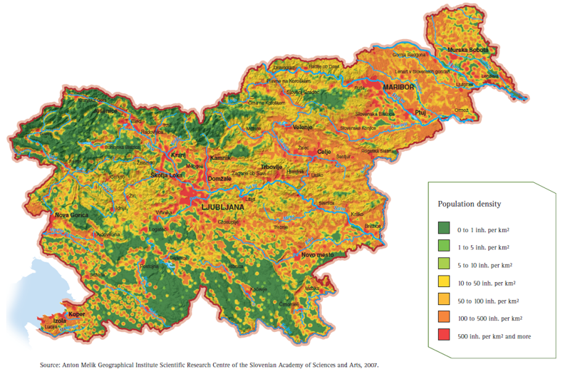
Source: Environment in the palm of your hand: Slovenia, 2008
Figure 7: Index of population, households and dwellings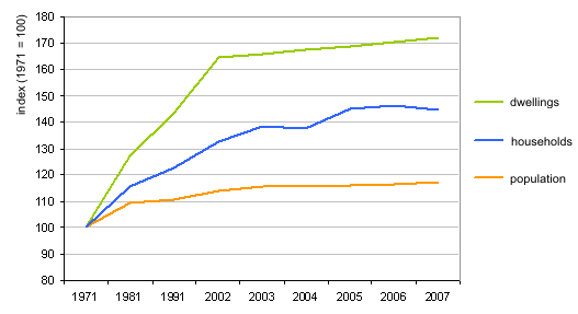
Source: Population census 1931–2002, Slovenian Statistical Office, Housing Fund, 2009, EUROSTAT, 2009 (Ref: Environmental Indicators in Slovenia, PG02, PG03)
Figure 8: Use of marine resources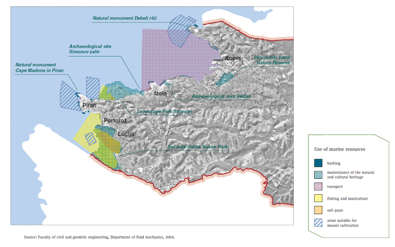
Source: Environment in the palm of your hand: Slovenia, 2008
Figure 9: Scope of investment in transport infrastructure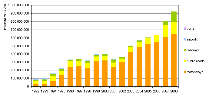
Source: Slovenian Motorways Company (DARS), 2009; Ministry of Finance, 2009 (Ref: Environmental Indicators in Slovenia, PR03)
What is the 2020 outlook?
Climate changes are a key factor in the scenarios covering impacts on land surface.
The forecasts indicate that climate change in Slovenia is likely to be greater than in the majority of European countries.
Slovenia’s demographics point towards declining fertility and slowing mortality, similar to other EU countries. The proportion of children is declining, while the proportions of work-active and older members of the population are increasing. This process is still slow, the result of relatively large demographic losses during the two world wars, and the proportion of older people still lags behind the EU average. Yet this could change in the next decade, when several generations born after World War II start entering the group of older members of the population, while the groups of children and work-active people will start to decline (MKGP, 2009a).
Development scenarios and documents indicate that, over the past 50 years, the average annual temperature in Slovenia has changed by approximately 1 ºC, which is higher than in most of Central Europe. The forecasts also indicate that climate change is likely to be greater than in the majority of European countries. Particular major impacts of climate change in the coastal Primorska region and in northeast Slovenia are anticipated. Climate change should have the strongest impact through both an increased threat of drought and of storms and associated flooding, soil erosion and other forms of damage to the land surface, structures, transport and other economic infrastructure. In forests, because of damage from extreme weather, snow, wind, frost splitting and tree pests, increased rehabilitation felling of timber is expected, and drought may be associated with a greater number of forest fires (MKGP, 2008, SVR, 2008).
Anticipated burdens by sector:
- Transport: plans call for the modernisation and upgrading particularly of the railway infrastructure in the European corridors running through Slovenia.
- Agriculture: we anticipate the merging of parcels of land and the increasing size of farms as a defence against the further collapse of agricultural holdings; construction of retention ponds as a measure for adapting to climate change and greater use of water for irrigation (MKGP, 2008).
- Energy: there are plans for the further construction of power stations on the Lower Sava, and a pump hydroelectric station at Kozjak (SVR, 2006). The River Mura is also being considered as a potential energy source. In light of the fulfilment of European objectives regarding the increased generation of electricity from renewable energy sources, major pressure will be put on all the renewable sources available in Slovenia: on surface watercourses, where pressure for increased hydroenergy use will also affect smaller streams with adequate hydroenergy characteristics; on increased use of solar energy, which will have significant consequences for the quality and identity of the cultural landscape – for instance the desire of individual investors to change slopes where agriculture does not pay into solar power stations; placing black panels on roofs, etc.
- Building: in the next 20 years, urban surfaces will probably expand three to five times more than the population, but the growth of cities and conurbations will be tied to existing patterns of settlement (MOP, 2000). With regard to the anticipated trend of population ageing and the economic crisis, in which construction was one of the hardest hit sectors of the economy, the extraordinary pressure for building and urbanisation may ease somewhat, and the development of towns and cities will be directed inwards – towards the comprehensive renewal of blighted or degraded existing urban areas.
The study Global vision of the spatial development of Slovenia cites five possible scenarios for future spatial development up to 2020. They are defined for the country as a whole and on regional, city and conurbation and countryside levels. These scenarios are divided into three basic so-called structural variants:
(1) spontaneous scenario – a continuation of current trends;
(2) economic and technological scenario; and
(3) the optimal or desired scenario, as well as two extreme variants:
(4) the conservative scenario – sectors predominate; and
(5) scenario of peripheral fragmentation (MOP, 2000).
What are the policy responses?
The basic applicable document covering spatial development is the Strategy of Spatial Development of Slovenia (Official Gazette of the Republic of Slovenia, No 76/2004).
Review of measures that address surface and land use
The aims of the Strategy of Spatial Development of Slovenia (Official Gazette of the Republic of Slovenia, No 76/2004) include the development of a polycentric network of towns and other settlements, settlement oriented towards urban settlements, rational use of physical space and control over the spread of urban areas, concern for the safety and quality of life and prosperity, and exploiting the comparative advantages of Slovenia in the context of European competitiveness (MOP, 2004). The objectives, priorities and orientations of the strategy must be heeded in drafting national spatial plans for spatial developments of national importance – motorways, railways, large-scale energy facilities of more than 10 MW, certain environmental infrastructure, and so forth – and in drafting municipal/inter-municipal spatial acts. Equally, potential discrepancies with the strategy are checked as part of the drawing up of departmental programmes and legislation.
Regional development is implemented on the basis of the Act Promoting Harmonious Regional Development (Official Gazette of the Republic of Slovenia, No 93/2005) and regional development programmes, which have been drawn up for 2007-2013 by the development councils of the 12 statistical regions and represent the needs of the regions. Programmes are based on regional development resources and include activities to promote the development of the economy, competitiveness and employment; development of human resources and access to services and jobs – road infrastructure, public transport; and improving the quality of life and resolving environmental problems such as upgrading or reconstructing drinking water supply systems, treatment facilities and infrastructure systems and infrastructure for waste management, the renewal of urban areas and the inclusion of natural and cultural heritage in development. The needs of the regions are supplemented through activities conducted by the state through departmental programmes and which are a part of the National Strategic Reference Framework, Operational Programmes and the National Development Programme.
In the past, agriculture facilitated a great diversity of species and habitats, and decisively shaped the cultural landscape. The formation of protected areas is a first step towards preserving traditional farm habitats. The proportion of agricultural land included in various forms of protection amounted to 25.1 % in 2007, with agricultural land covering 19.7 % of all protected areas – the majority of protected areas are forested, 71.2 % (KM06).
Agricultural areas with high natural value represent some of the most important for preserving biodiversity and protecting threatened habitats, since these are areas of extensive farming with a high diversity of species and habitats. These areas represent 20-30 % of Slovenia (KM05).
Agricultural policy started implementing the first measures to support environmentally-friendly farming methods in 1999, and to a greater extent after adopting the Slovenian Agri-environmental Programme in 2001. The first year, 2001, saw the trial implementation of ten measures, and in the ensuring years the number grew to more than 20. After EU accession, support under the Agri-environmental Programme became part of the Slovenian Rural Development Programme (KM03). In addition to agri-environmental measures, the programme also promotes the diversification of activities in the countryside in support of developing rural employment. Under the 4th access of the programme (LEADER) a total of 33 local action groups were formed, covering a total area of 19,350 km2. These groups have formulated their own development strategies and are contributing to the strengthening and use of local potentials in the countryside, for instance activities promoting cultural and natural heritage, creating trademarks, marketing agricultural products, etc.
From year to year there has also been a greater response of agricultural holdings to agriculture policy that supports the spread of organic farming. The surface area of land intended for organic farming grew in 1999-2007 from 2 400 ha to 29 322 ha, or from 0.5 % to 5.9 % of all agricultural land in use (KM08).
The Forest Act (Official Gazette of the Republic of Slovenia, No 30/93) and the Forest Development Programme (Official Gazette of the Republic of Slovenia, No 14/96) set up the basic national policies of forest management. Their primary aims are to ensure the co-natural and multi-purpose management of forests, the development of guidelines for the conservation and development of forests, the long-term and optimal functioning of forests as an ecosystem and the fulfilment of their functions.
One of the most important and oldest mechanisms for preserving plant and animal species and their habitats is the setting up of protected areas, and on entry into the European Union Slovenia also established ecologically important areas and special protection areas – Natura2000 areas. Today 12.57 % of the country’s territory is listed as protected areas (NV02) and 52.16 % as ecologically important areas, 35.5 % protected as part of Natura2000, and, since 2008, a further 1.7 % as part of areas considered by the European Commission to fulfil the conditions for special protection but not yet designated as Natura areas (NV03).
The main document for water management in line with the Waters Directive is the Water Management Plan. The drafting of a water management plan for the watersheds of the Danube and Adriatic Sea in 2010, currently being debated, is the first to attempt a comprehensive approach to analysing the issues associated with achieving both environmental objectives and those for the use and regulation of water. On this basis preparations are also in hand for a programme of measures to achieve water management plan goals in both watersheds, and the plan is awaiting intergovernmental harmonisation (IZVRS, 2009).
In accordance with Directive 2007/2/EC establishing an Infrastructure for Spatial Information in the European Community (INSPIRE), Slovenia adopted the Infrastructure for Spatial Information Act (Zakon o infrastrukturi za prostorske informacije, Official Gazette of the Republic of Slovenia, No 8/2010) at the beginning of 2010. This regulates the establishment, managing and maintenance of infrastructure for spatial information as a constituent part of the European infrastructure for spatial information.
There are several web applications available for facilitating access and viewing of this information. The Slovenian Environment Agency provides access to environmental information through the Environmental atlas of Slovenia, while there is also a metadata portal (metapodatkovni portal) and web services for transmitting information to the user. The Surveying and mapping Authority of the Republic of Slovenia offers information through the web portal Prostor. It is aimed at improving access to geographical, geodetic and other spatial information in Slovenia. In this way other users can use the same information that state institutions use in their work. Slovenia has also initiated a spatial information system project aimed at the interoperable linking of spatial information to support more transparent and effective spatial planning.